
Contract awarded for Buffalo Reef dredging
Trending
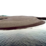
DETROIT -- Dredging of stamp sands between Gay and Grand Traverse Harbor is now slated to take place next summer.
The U.S. Army Corps of Engineers last week awarded the contract to Petersen Companies of Minocqua, Wisconsin. The company will dredge about 27,500 cubic yards of stamp sand at the Grand Traverse Harbor, along with 80,000 cubic yards of stamp sands from an ancient riverbed area north of Buffalo Reef.
Currents had pulled stamp sands at Gay north to the harbor and reef. The sedimentation has covered 35 percent of the 2,200-acre Buffalo Reef. The area is a critical breeding ground for lake trout and whitefish.
The dredging had been scheduled to take place this summer.
"We had some real-estate issues that came up that forced some design changes so that we were not encroaching on what was perceived as any riparian ownership issues," said Steve Check, project manager with the U.S. Army Corps of Engineers in Detroit.
The changes reduced the amount of material being dredged by about 10,000 yards, Check said. It also shrank the disposal area for the stamp sands, though it will still be sufficient to hold the amount that will be removed, he said.
There was also concern about the maps that detailed the ancient riverbed area by the trough, which dated from the early 1900s, Check said. That was before the designation of a universal vertical datum, or base measurement point. That posed problems when attempting to calibrate their models to determine how much stamp sand was by the trough.
They did additional test pits "so we can make sure we're dredging only stamp sand and limiting the amount of sand that could be native sand," Check said.
The project is a collaboration between the U.S. Army Corps of Engineers, U.S. Environmental Protection Agency, Keweenaw Bay Indian Community, Michigan Department of Natural Resources and Michigan Department of Environmental Quality. The work has been funded through the federal Great Lakes Restoration Initiative.
Work is also progressing on a long-term solution to the stamp sand erosion. Last week, the Army Corps of Engineers deployed wave gauges. The U.S. Geological Survey will also be out doing the bathymetric survey next week.
"Both of those products will help inform the hydraulic model that's being used by the Corps to help understand what's going on in the littoral drift of the sand," Check said.
The groups are also close to a draft suggesting alternatives for combatting the drift of stamp sands and finding other uses for them. Members of the public provided suggestions at a meeting in February.
"We'll have a draft that details all those different alternatives that were out there and lays out the risks associated with those different alternatives," Check said. "Our plan is to present that to the public to gather some comments and get some reaction to the comments that were out there."
That will be done through combinations of public forums and soliciting comments online, Check said.