Are we making history?
snowfall ahead of last year

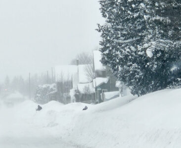
Paula Porter/For the Gazette These homeowners heads peer above the hefty snowbanks in Calumet Monday morning.Visit Keweenaw reports this year's snowfall is about three feet ahead of last years.
HOUGHTON — With snowfall totals continuing to climb and lake effect expected through the week, one question is starting to surface across Michigan’s snow belt — Is the Keweenaw on track for a historic winter?
According to a press release from Visit Keweenaw, as of Monday, the Keweenaw Peninsula has received 187.75 inches of snow, far outpacing last winter’s snow at this same point. By comparison, only 143.25 inches had fallen by late January last year — a difference of more than three feet.
For additional context, February has historically played an outsized role in the Keweenaw’s snowiest seasons. Just last winter, the region picked up 91 inches of snow in February alone. Looking back over the past two decades, the single snowiest month on record was December 2013, when an incredible 126 inches fell across the peninsula — a reminder that big monthly totals are always possible under the right conditions.
With the cold temperatures over the weekend, organizers had to move the Polar Plunge to Feb. 7, when warmer temperatures are expected. The momentum isn’t slowing. Conditions became so intense that Michigan Technological University announced a closure Friday — a rare move for an institution famously accustomed to heavy snowfall and harsh winter weather.
That said, the Keweenaw’s snow machine is partially dependent on Lake Superior remaining “open.” Prolonged stretches of extreme cold can slow lake-effect production by allowing ice to form, reducing the moisture fueling these intense snow bands.
Historical trends also offer a note of caution. Years that follow a pattern similar to this season — moderate November snowfall (30″), strong December totals (75″), and a robust January (80+”) — have often been followed by a more modest February, averaging closer to 50 inches, before tapering off into March and April.
While that history suggests the all-time snowfall record may remain intact, winter forecasting is never an exact science. And in the Keweenaw, surprises are always on the table.
For context, the Keweenaw’s all-time snowfall record sits at 390.4 inches. While it’s far too early to make any guarantees, the current pace has snow watchers, meteorologists, and winter enthusiasts alike beginning to speculate: Could this be the season the Keweenaw challenges — or even breaks — its historic record?
What is clear is that winter is firmly in control across the peninsula. Snow conditions at area ski hills are exceptional, snowmobile and cross-country ski trails are deep and well-groomed, and the region is fully living up to its reputation as Michigan’s snow capital.
Whether or not the record ultimately falls, one thing is certain: winter in the Keweenaw is having a moment — and it’s not done yet. Keep an eye on every inch that falls on Visit Keweenaw’s Snowfall & Trail Conditions page.