Not ending soon
Winter weather continues

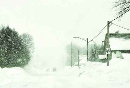
Paula Porter/For the Gazette Winter has not left the Keweenaw yet as proved by white out conditions Friday morning in Calumet.
HOUGHTON – Winter weather returned this week with a severe storm after a false spring brought above-normal temperatures over the previous 10 days. Wednesday’s storm dumped more than 20 inches of wet, heavy snow, driven by high east winds, on the Keweenaw. On Friday, another weather system pushed through the area, adding several inches more.
The Keweenaw County Road Commission’s website Friday reported this season’s snow total stands at 249.5 inches. Meteorologist Nick Langlieb, with the National Weather Service in Negaunee, said more is on the way. “Overall, the Climate Prediction Center is calling for better chances of above-normal temperatures and above-normal precipitation over the next two weeks,” Langlieb said.
“There is a 30% chance for above-normal temperatures, and a 30-50% chance of above-normal precipitation. It’s definitely leaning toward the warmer and wetter side of things. The next several days here are going to be pretty wintery.”
Langlieb said it is a bit early for spring weather patterns, but going into late February and early March, wetter, warmer weather systems become more frequent.
“It’s definitely getting more active,” he said. “Through much of January, we were in a pretty cold pattern with colder, dryer air. A lot of our snow was lake-effect, with weaker systems coming through. Now, we’re into a warmer pattern. It’s more spring-like. We’ve got more systems working through over the next few weeks here.”
The 2024-2025 winter is reported as the fourth snowiest season on record, at 315.25 inches. This winter could still easily top that. The Keweenaw County Road Commission reported 24.25 inches of snow between Tuesday and Thursday. KCRC’s website says January’s total was 103.75 inches compared with 79.87 inches in Jan. 2025.
“In the Keweenaw particularly, when we were in the really cold pattern,” Langlieb said, “we continued to get continuous lake-effect snow, where other areas of the U.P. were cold, but other areas like in the southern U.P. were only carrying a few inches of snow. Those cold, Arctic air masses you get that steady west, northwest airflow and it’s great for lake-effect snow, and the terrain of the Keweenaw just enhances it.”