Keweenaw dodges a bullet
Most of UP not so lucky
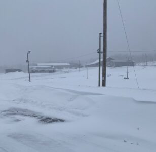
Graham Jaehnig/Daily Mining Gazette While the Keweenaw did not get the predicted snowfall amounts, cold temperatures on Monday provided good trail conditions for late-season snowmobilers, with all trails reported open.
HOUGHTON – A blizzard warning issued for the Upper Great Lakes for Sunday and Monday did not produce the snowfall totals predicted for the Keweenaw Peninsula, but the central, east and southeast Upper Peninsula were heavily impacted.
Meteorologist Ryan Metzger, head of the National Weather Service in Negaunee said the storm tracked a bit differently than models predicted – just a bit.
“I think you really dodged a bullet,” Metzger said. “The system shifted a little bit more to the southeast, so the Houghton area really didn’t get nearly as much snow as we were thinking originally.”
The Keweenaw County Road Commission recorded 4 inches of snow Sunday. County Undersheriff Tanya Mattila said with the exception of high winds, the Sheriff’s Office received no reports of weather-related accidents or crashes.
“Things were quiet over the weekend,” said Mattila. “The Road Commission had to deal with a lot of drifting along M-26 between Eagle River and Copper Harbor, but other than that, things were quiet.”
The Houghton County Sheriff’s Office offered a similar report Monday afternoon. Sergeant Cort Rajala said the department did not log any reports of weather-related reports.
Hancock City Police Chief Tami Sleeman said her department did not even receive the usual snow plowing complaints.
“It was nothing,” she said. “We got absolutely nothing. We’ve had no complaints, no accidents. But, then people haven’t been out running around, either.”
Other areas across the U.P. were not so lucky. Metzger many parts of the U.P. had received more than 20 inches of snow by Monday morning with another foot predicted for that afternoon.
“Here in Marquette county,” he said, “we’ve had quite a significant amount of snow. The last time we measured, at 8 a.m. we had 21.4 inches, here at the office in Negaunee.”
There are places in Marquette County that reported 30 inches of snow, Metzger said. The southern U.P. got struck hard by the blizzard, and in the northern Lower Peninsula, ice storms caused significant power outages.
Due largely to high winds, a hazardous weather warning continue through 2 a.m. Tuesday morning across the Keweenaw.
The NWS Harzardous Weather Outlook through Monday night states Additional snow amounts of five inches (mainly west) to two feet (mainly Lake Superior-facing terrain) are expected. Wind speeds of 35-65 mph are expected through this evening. Strongest winds are expected for the Keweenaw Peninsula and along the lakeshores of Lake Superior.