An irregular compass reading changed everything
Iron ore put Michigan on the map
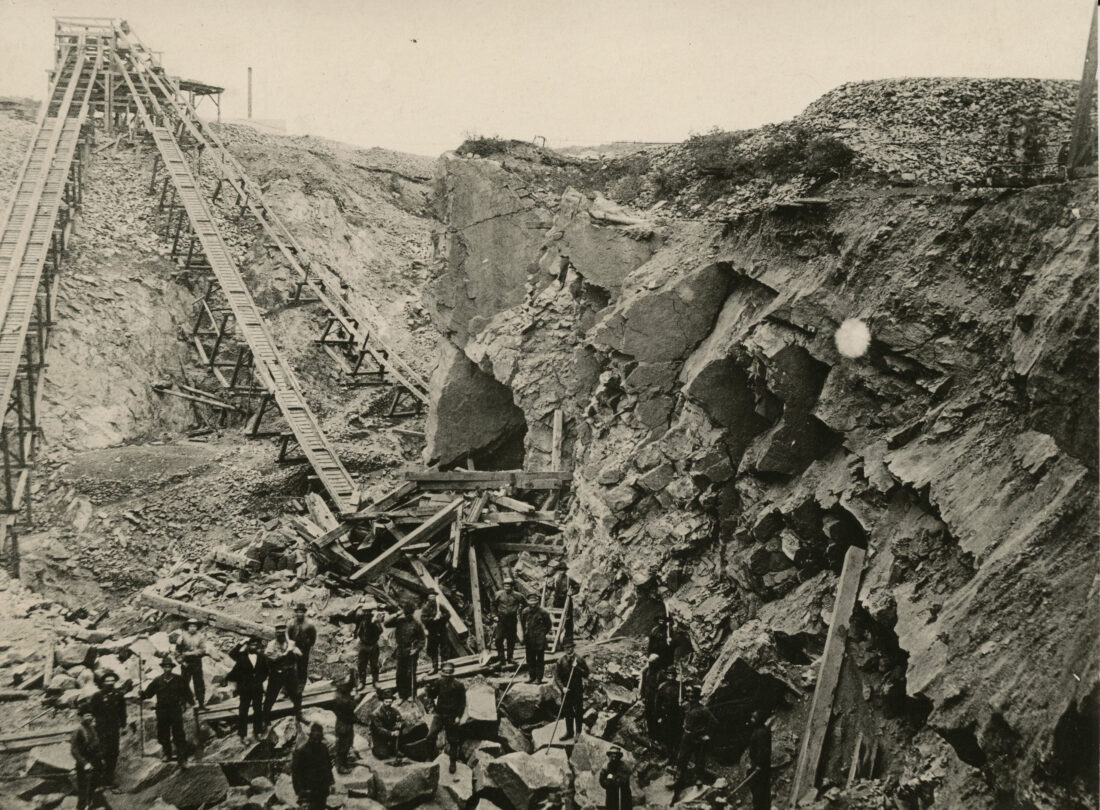
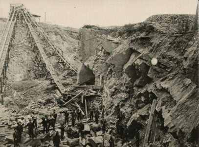
Photo courtesy of the Marquette Regional History Center Cleveland #3 open pit mining is shown in Ishpeming in 1879.
Editors note: Beginning today the Daily Mining Gazette, in cooperation with other Upper Peninsula papers, will run companion pieces to our America 250 stories with a focus on the U.P.’s role in building America.
Compiled from Marquette Regional History Center articles
Following the Revolutionary War, the U.S. General Land Office was formed in 1812 to survey public lands. The newly created U.S. government, which needed funds, wanted to distribute the land to war veterans as a reward and to sell land to raise funds. The Public Land Survey divided the territory into a grid system of townships, sections and quarter sections to promote ownership and development.
Surveyors were contracted by the federal government and had to include the variations of every line they ran; the name and diameter of all bearing trees; the surface — level, rolling, broken, hilly; the quality of soil; the type of timber and undergrowth; the rivers and their courses; all springs; all ponds, including the banks, water depth and quality; waterfalls and mill sites; all towns, camps, furnaces and constructions; all minerals and ores; and roads and trails.
Traditionally, surveyors used a special metal chain for measuring distances along with a spring and thermometer. Tension and temperature of the metal all affect the measurement. A rod was used in finding elevation. A survey party might consist of a surveyor, rodman and two chainmen.
Surveying Michigan Territory began in 1815 with the establishment of a base line and prime meridian. When the territory was first surveyed, a wooden post was used to mark each section and quarter section.
Around each post were up to four bearing trees (also known as witness trees). They were each blazed or marked. The trees’ species, diameter, and location — the distance and direction from the post — were all recorded in a log book.
Later survey markers or monuments, often made of metal, were placed at key survey points on the Earth’s surface.
Most of the Lower Peninsula and eastern Upper Peninsula were completed by 1840. However, much of it was found to be inaccurate and even fabricated. One story circulated that the surveyors simply sat around a tavern and made up the terrain in northern Lower Michigan.
One of the surveyors defended himself, claiming no one was harmed and the land was worthless: “Was ever any individual or even was the United States injured? Was the country worth a cent? No, the land will not be sold in 10 centuries,” which was quoted in “Getting Southern Michigan into Line,” Michigan History Magazine J/F 2003, p. 26.
In the 1842 Treaty of La Pointe, the Ojibwe ceded extensive tracts of land that are now the western half of the U.P. and the northern part of Wisconsin.
Two years later, William Austin Burt and his survey crew “discovered” what the Anishinaabe already knew — that this area held rich iron ore deposits.
On Sept. 19, 1844, near Teal Lake in what is now Marquette County, Burt and his men found their compasses acting in a most irregular fashion. A search for the cause revealed numerous specimens of magnetic ore — the Marquette Iron Range.
Burt went on to invent the solar compass, which is not affected by the magnetic charge of iron ore and became the standard tool. The survey of Michigan was finally completed in 1851.
Iron from the Upper Peninsula helped spur the nation’s industrial growth and the development of the local communities.
The need for manpower at the mines drew thousands of immigrants to the region from Cornwall, Finland, Sweden, Italy and many other countries. Once the companies lured men to the area, they also had to provide living facilities for them, building housing, company stores, schools and hospitals to service the miners and their families.
Soon after mining began, forges were built to reduce the bulk of high grade ore before shipping. The increasing need for charcoal to fuel the forges in turn created a forest industry, filled either by independent contractors or a new division in the mining company
Once concentrated, the iron blooms or pig iron were ready for transportation. Several companies cooperated to build a plank road, for the carts pulled mules and horses. But the heavy carts moving downhill on wooden planks were hard to control and the breaking systems poor, leading to frequent accidents.
In an effort to better control the wagons, wooden “rails” were laid on the planks and capped with iron straps. The cart wheels were made to these rails. The transition to railroads occurred when steam engines with more power and rail cars with more efficient braking replaced the horses, mules and carts.
Once the ore reached the harbor in Marquette, wooden sailing ships were loaded by hand at a rate of 50 tons per day by men pushing wheelbarrows. At Sault Ste. Marie, the ore had to be off-loaded, carted around the rapids on the St. Mary’s River and reloaded on a new ship.
In response to this bottleneck, a lock at the Soo was constructed in 1855 under the supervision of Charles T. Harvey. Ships could then be raised or lowered past the rapids, avoiding the costly and time-consuming portage.
Pocket docks were developed to reduce the loading times. Eventually, ships were designed specifically for hauling ore and marine companies were formed to meet the shipping needs.
The mining companies have mined iron ore in Marquette County for nearly 200 years, leaving an indelible stamp on our communities. In the early days, “the company” owned or controlled almost everything. It owned the store, provided the utilities, and owned almost all of the houses workers lived in.
Wresting iron ore from the surrounding hills became tradition for generations of families. The industry employed tens of thousands of miners during its life; few families were not touched by someone who worked in the mines.