
Trending
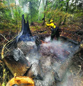
BARAGA COUNTY -- Rustic terrain, falling trees, slippery rocks and impassible roads are just some of the hazards confronting Michigan Department of Natural Resources (DNR) firefighters across three active Upper Peninsula wildfires totaling a combined 1,454 acres.
According to DNR statements. precipitation has helped reduce active surface fire behavior. However, the rainfall has simultaneously created slippery rock hazards and softened forest soils, significantly increasing the difficulty for heavy equipment to access the landscape and raising the risk of machinery getting stuck in deep mud.
A single, unified 20-person DNR Incident Management Team is currently directing overall operations for both the Ridge Fire in Marquette County and the Craig Lake Fire in Baraga County. There are a total 65 field firefighters deployed across both the Craig Lake and Ridge fires.
The DNR stated that due to prolonged drought conditions across the U.P., suppression efforts were heavily hampered by the duff layer--the dense accumulation of partially decayed needles, leaves, and organic matter sitting beneath loose top litter and directly above solid mineral soil. Because the fire lives at these depths, surface rain cannot easily extinguish the core embers. The fire systematically burns through the root systems of otherwise healthy-looking green trees, causing them to fall without warning. Incident commanders warned that high wind gusts moving through Friday have significantly increased the danger of falling trees for ground personnel.
The Craig Lake Fire, located north of Craig Lake State Park between Baraga and Marquette counties, has burned an estimated 606 acres and is 57 percent contained. First detected by an air patrol pilot on October 8, the DNR confirmed the blaze was sparked by a lightning strike from storms that moved through the peninsula earlier this month.
North of the fire location, theDNR has temporarily closed Craig Lake State Park due to ongoing fire operations, along with the Teddy Lake Yurt, and the internal segment of the North Country Trail through the end of October. A five-nautical-mile temporary flight restriction remains enforced below 3,500 feet over both the Craig Lake and Ridge zones, strictly banning personal drones which immediately ground defensive air operations.
The Ridge Fire, located 10 miles northwest of Marquette and north of the Dead River Basin, is mapped at 466 acres and remains 30 percent contained. Discovered on October 9 west of County Road 510, its cause remains under investigation. Ground crews are hampered by steep terrain on the perimeter, aided by property layout data provided by local private landowners.
Under the regional “Ready, Set, Go!” safety protocol, residents along North Basin Drive remain at a “Ready” alert status. The neighboring Noquemanon Trail network west of the County Road 510 trailhead is closed.
In Gogebic County, the Black River Fire, located approximately four miles south of Wakefield, is managed by multi-agency crews. The blaze is holding at an estimated 382 acres and is 50 percent contained, with 60 personnel on-site east of County Road 519.
On Wednesday, Wildfire Explorer reported that heavy equipment operators have established complete bulldozer containment lines along portions of the fire’s southern perimeter. Where muddy soil conditions restrict heavy machinery, hand crews are manually scraping containment lines along sections of both the northern and southern flanks. Bounded on the west by the natural barrier of the Little Black River, the fire poses no immediate threat to nearby structures.
Cooperating on the Black River Fire suppression are the U.S. Wildland Fire Service, the Keweenaw Bay Indian Community, the Bay Mills Indian Community, the Marquette National Weather Service, the Gogebic County Sheriff's Office and Emergency Management, the Bessemer Township and Wakefield local fire departments, the U.S. Forest Service Ottawa National Forest, and assisting crews from the Minnesota and Wisconsin departments of natural resources.