First snowstorm of winter
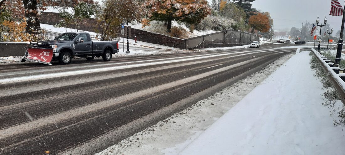
Garrett Neese/Daily Mining Gazette Plows were back out Monday morning following the first large snowfall of the year throughout the Copper Country.
HOUGHTON — Winter has arrived, at least temporarily.
The Copper Country got hit with the first snowstorm of the season Monday, with more on the way.
Early Monday morning, the southern part of the Copper Country was getting hit the hardest, the National Weather Service said. A station at the Bergland Dam reported 12.3 inches as of 8 a.m. Monday. Nisula had received 8 inches.
Totals farther north were lower: 4.2 inches in Twin Lakes by 9 a.m. Monday, and 2.3 inches in Calumet at 9:15.
A colder northern airmass moving over Lake Superior is behind the swath of lake effect snow.
“It’s the temperature difference between the water, which is still running 48 degrees on the western lake, and the air moving across it, which is considerably colder,” said Don Rolfson, a NWS meteorologist in Negaunee.
The storm was enhanced by a disturbance moving through the area in the mid-level of the atmosphere. As moisture depth increases in the atmosphere, it reduces stability over the water, intensifying lake-effect snow, Rolfson said.
More is coming. Converge with a system dropping through the Northern Plains will affect part at least part of the Keweenaw tonight. The western shoreline north of Houghton could see between 4 to 7 inches overnight. Houghton might see a lower total of 2 to 4 inches.
“There’s some uncertainty,” Rolfson said. “A little shifting of the band and Houghton could see a lot more snow. It’s always a fine line, trying to determine where the snow’s going to be.”
Some snow showers will linger into Tuesday, but should wind down by Tuesday evening, Rolfson said.
Longer term, winter should be warmer than normal thanks to a pronounced El Niño effect. Even then, the area should still see large snowfalls from cold air masses crossing the lake, Rolfson said.
Local departments were busy on the first day for winter traffic.
Houghton police had responded to three traffic crashes as of about 4 p.m. Houghton County had responded to four, primarily two-car crashes, said Sheriff Joshua Saaranen.
“We have been seeing vehicles in the ditch,” he said. “We assisted with a school bus unable to get up a steep hill that was snowy and icy. We’re trying to be out there to respond to the complaints and trying to get traffic to slow down a little bit.”
Saaranen urged drivers to take their time, and leave a little earlier than usual to get to their destination on time safely. They should also be watchful and display extra caution around school buses this time of year, he said.
Houghton-Portage Township Schools had two buses that got stuck and either slid or were slid into by cars, Superintendent Anders Hill said in an e-mail to parents Monday morning. All students were uninjured and safe. Additional buses came to take the students to school.
Hill asked people to slow down in parking lots. He also reminded them of the laws regarding school buses. Yellow flashing lights require drivers to slow down, and red flashing lights mean they must stop.
“Hopefully this is just a short taste of winter and we have a little time before it comes and stays,” he said in the e-mail.
Waste Management also pulled their trucks off the road because of bad weather, the City of Hancock said in an email to residents. It will finish garbage and recycling pickup on Tuesday. Wednesday’s pickup was also pushed back a day.
Front Page

City council approves rezoning of E. Lakeshore Drive
Scientists find proof of invasive shrimp in Lake Superior
Finno-Ugric Forum to kick off Juhannus festival
HANCOCK — What can Finno-Ugric peoples in Europe learn from Finnish Americans? And what can Finno-Ugric ...

Morrison speaks on jail committee’s recent meeting

Removal of invasive species in the L’Anse/Baraga area has begun