
DNR reduces firefighter numbers
Down to 27 as of Wednesday
Trending
MARQUETTE -- Michigan Department of Natural Resources (DNR) fire officials reduced the number of active field personnel down to 27 firefighters Wednesday morning, moving into a localized monitoring phase as Rugged Terrain Complex volatility comes under complete control, according to a DNR social media update.
The personnel reduction follows a week of heavy suppression operations across the three regional zones. DNR Deputy Incident Commander Jennifer Hansen said in a press release that because ground crews secured stable containment lines and successfully checked surface flames, active firefighting is winding down to focus exclusively on patrolling perimeters and neutralizing hidden subterranean hot spots.
"Because firefighters have done such a fantastic job with suppression efforts, we can reduce resources actively working these fires," Hansen said in the release. "We are finding fewer hot spots, which allows us to move into more of a monitoring strategy. Staff continue to check and extinguish the hot spots they can safely reach."
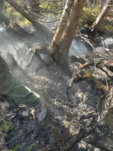
A continued threat to firefighter safety as well as containment efforts are the trees damaged in the fires, some of which have had their roots burned right out from under them, according to the DNR's social media post. Those trees have been falling across containment lines, interrupting necessary access for firefighters to complete remaining suppression efforts.
According to the press release, mopping up is the process of identifying locations where pockets of smoldering material exist, then managing those areas accordingly. Commonly referred to as hot spots, duffers, or smokes, these locations of remaining fire activity are tracked down by crews executing an activity called "cold trailing." Firefighters then open up the smoldering areas to surface weather conditions and douse the embers with water.
Water is delivered to ground crews in several ways, including engines or utility terrain vehicles where access is available, or by a network of pumps and hoses for firefighters on foot. On the Black River Fire alone, nearly two miles of motorized hose spread like tree branches through the forest canopy to provide water access.
To maximize the effectiveness of on-the-ground firefighters, DNR pilots have deployed drone-mounted infrared cameras to determine the precise locations of strong heat signatures, where subterranean temperatures are significantly higher than ambient air temperatures. Less than three hours from drone liftoff, ground crews receive specific GPS coordinates alongside the size and density parameters of lingering fire behavior.
On the Rugged Terrain Complex, addressing residual heat locations adjacent to secured containment lines remains the immediate priority, with mop-up work then progressing toward the interior of the burned area. This increases the effective width of areas which block fire from spreading, leading to a reduced risk of a perimeter restart. These final cleanup steps will be ongoing for weeks to come.
"There is still quite a bit of work to do, but the volatility of these fires is under control," DNR Fire Specialist Keith Murphy noted in a statement. "Realistically, portions of these fires will not be truly extinguished until there is sufficient snow cover. Until then, we will keep many watchful eyes on each of them."
The DNR social media page provided updated operational parameters for the three primary complex zones across the peninsula:
• The Ridge Fire: Mapped at 466 acres, containment holds steady at 50 percent. The cause remains under investigation. While residential property alerts along North Basin Drive were canceled Monday, the Noquemanon Trail system west of the County Road 510 trailhead remains strictly closed to the public.
• The Craig Lake Fire: Positioned in Baraga County, the complex's largest single footprint is holding at 606 acres and is 90 percent contained. A lightning strike remains the confirmed cause. To protect public safety during ongoing mop-up efforts, Craig Lake State Park north of Craig Lake proper, the Teddy Lake Yurt, and the local segment of the North Country Trail remain closed through October 31, while the remainder of the park is open.
• The Black River Fire: Precision mapping trimmed the active footprint estimate down to 326 acres south of Wakefield in Gogebic County. The blaze holds at 70 percent containment under a verified lightning cause. The public is instructed to entirely avoid the area to prevent interference with active crew monitoring.