Under water
NWS issues flood watch
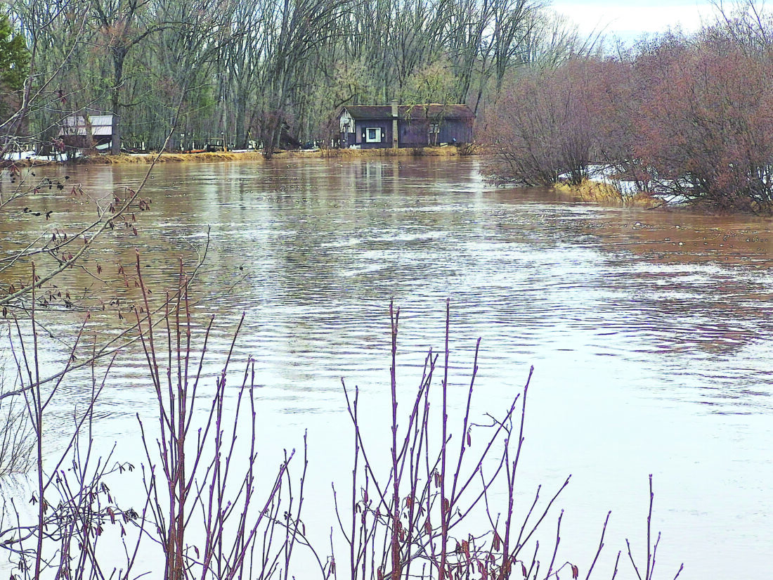
Graham Jaehnig/Daily Mining Gazette The Sturgeon River as of Monday is at 10.60 feet. It’s flood stage is eight feet.
HOUGHTON COUNTY – The National Weather Service has issued a flood watch for the entire Upper Peninsula through Wednesday.
The statement, issues at 8:30 a.m. Monday, said heavy rain may fall on a deep primed snowpack leading to the melt increasing. Flows in rivers may increase quickly and reach critical levels. Excessive runoff may result in the flooding of rivers, creeks, streams and other low-lying and flood-prone locations. Flooding may occur in poor drainage and urban areas.
Meteorologist Nick Langlieb with the NWS office in Negaunee said there are a few rivers in the U.P. that are either reaching, or are going to reach, minor flooding closer to the Keweenaw, the largest of which is the Sturgeon River.
Flood stage of the Sturgeon River, he said, is eight feet. As of Monday, it was measured at 10.60. feet.
Langlieb said currently the chief concerns are heavy rain and rapid snow melt.
“The main thing is that we’ve got a lot of water in the snow around the Keweenaw, and we’ve got areas with 15 or more inches of water within that snowpack,” he said. “We’re getting well into April and there’s still a lot of water locked up and that’s why it’s a watch, because there is a potential for flooding. It’s all going to depend on how fast that snow melts.”
Langlieb said right now, the focus is on heavy rain associated with thunderstorms, but at least for now, they do not appear to be a major threat.
“Right now, it’s looking like the guidance is trending towards pushing the thunderstorms more down into the Wisconsin area and not so much for the U.P., which would be great, because we don’t want thunderstorms on top of deep snowpack,” Langlieb said.
Langlieb said weather models show an active weather pattern through next week.
“Monday night there was about a 70% chance for showers and thunderstorms,” he said, “but again it looks like the heavier stuff had shifted to more like Wisconsin rather than the U.P.”
The next high chance of precipitation will be Friday night, when a front is expected to move through the area.
“We’re looking at 90% chance so a really good chance we’re going to see some showers,” he said. “The downside is there could be some snow showers by Saturday night.”
There are some models, he said, that are predicting wet, heavier snowfall, but there too much uncertainty so early in the week. Moving deeper into the spring season, temperatures are borderline and they fluctuate, making accurate extended forecasts regarding snow more difficult to predict.
Front Page
UP’s jobless rate dips below 6%
IRON MOUNTAIN — The Upper Peninsula’s not seasonally adjusted unemployment rate fell to 5.9% in May, down from ...
Easing holiday travel
Workin’ on the railroad
A rainy month

The circus is coming to town